

Greater Palm Springs history dates back long before the arrival of the steam engine. Some archaeological evidence suggests the first Native people have resided in the area for more than 8,000 years.
Today, five tribes representing two major Native cultural groups reside in the area that makes up Greater Palm Springs. They are:
- Agua Caliente Band of Cahuilla Indians
- Augustine Band of Cahuilla Indians
- Cabazon Band of Mission Indians
- Torres-Martinez Desert Cahuilla Indians
- Twenty-Nine Palms Band of Mission Indians
There are other federally recognized tribes of the Cahuilla people in the region, from Thermal and Banning to Anza. Those tribes are the Cahuilla Band of Mission Indians of the Cahuilla Reservation, Los Coyotes Band of Cahuilla and Cupeno Indians of the Los Coyotes Reservation, Morongo Band of Cahuilla Mission Indians of the Morongo Reservation, Ramona Band of Cahuilla, and Santa Rosa Band of Cahuilla Indians.
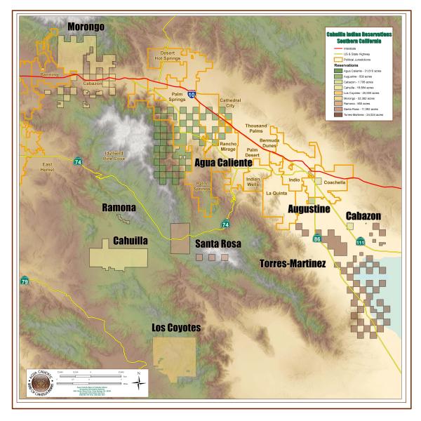
Below is a map showing the reservations of these tribes. (Map is courtesy of the Agua Caliente Band of Cahuilla Indians.)
Agua Caliente Band of Cahuilla Indians
With a documented history dating back at least 5,000 years–and recent archaeological evidence suggesting the Tribe’s history stretches back 8,000 years–the Agua Caliente Band of Cahuilla Indians makes its physical and spiritual home at the corner of North Indian Canyon Drive and East Tahquitz Canyon Way in Palm Springs.
This major Palm Springs intersection is the site of a soon-to-open, expansive cultural plaza that sits atop the original mineral hot spring that has been bubbling up from deep underground since time immemorial. The spring, sacred to the Tribe, was called "Séc-he," which means "the sound of boiling water" in the Cahuilla language. Thanks to an abundant water source, not only from the spring but also from year-round streams flowing down to the desert floor from the surrounding mountains, the Agua Caliente were skilled farmers, growing the Native trinity known as “the three sisters”–squash, corn, and beans.
Some of the early Cahuilla civilization can still be seen at Tahquitz Canyon and the Indian Canyons, both listed on the National Register of Historic Places, and both spiritual locations for the Tribe.
It is a well-documented, but not well-known, fact that the land comprising the Agua Caliente reservation is not contiguous. Rather, it's partitioned into grid-like segments that resemble a checkerboard, with alternating stretches owned by the Tribe.
The Tribe was federally recognized in 1876, when President Ulysses S. Grant designated two even-numbered segments–Section 14 (Downtown Palm Springs) and a portion of Section 22 (Tahquitz Canyon), as the Agua Caliente Indian Reservation. The following year, additional even-numbered sections totalling more than 30,000 acres were added to the officially recognized reservation land.
Checkerboard partitioning was not unique to the Agua Caliente, nor was it uncommon throughout the Western U.S. and Canada, but the story remains largely untold in history books. The Agua Caliente band most famously drew attention to checkerboarding in the blockbuster museum exhibition Section 14: The Other Palm Springs, California, which was created in partnership with the Smithsonian’s National Museum of the American Indian.
In the 1950s, the passage of two laws set into motion significant infrastructure developments throughout Greater Palm Springs, including allowing the Tribe to sell the land it had been previously leasing to the City of Palm Springs. Built on that land was the Palm Springs Municipal Airport, which was a prominent military base during World War II and which would later become the Palm Springs International Airport.
Augustine Band of Cahuilla Indians
The Augustine Band of Cahuilla was once the smallest tribal nation in the United States. Today, the Augustine Band of Cahuilla Indians has grown into a thriving community with an economy to match.
As with other area tribes, the history of the Augustine Band dates back thousands of years. It got its name from Tribal Chairman Captain Vee-Vee Augustine, who led the Tribe in the mid-1800s.
Congress formally recognized the Augustine Reservation on December 29, 1891, using a United States Land Office surveyors map’s reference to a “Cahuilla Village” as their pinpoint for the reservation site.
By the early 1970s, the Tribe had declined to just one enrolled member–Roberta Augustine, the great-granddaughter of Captain Vee-Vee. It was Roberta’s three children who would re-establish the Tribe. In 1988, they organized a tribal council and launched plans to build an economy that would support the rebirth of the Tribe. A local casino was carefully planned, intentionally built on a smaller scale so as not to compete with the nearby Vegas-style casinos popping up on Indian lands.
Economic development continues for the Tribe. One of the original 22 villages is now home to the thriving Temalpakh (From the Earth) Farm, where visitors can stop in to purchase organic produce grown by Tribal members.
Cabazon Band of Mission Indians
The Cabazon Band of Mission Indians are descendents of Chief Cabazon, who led the Desert Cahuilla from the 1830s to the 1870s. The Tribe, which gained federal recognition in 1876, has called the Coachella Valley home for more than 2,500 years.
Torres-Martinez Desert Cahuilla Indians
The Torres-Martinez Desert Cahuilla Indians have made their home in the southeastern part of Greater Palm Springs since the early 1800s, with their reservation divided across Riverside and Imperial counties.
Once two reservations, the Torres (named after the Toro Indian Village) and the Martinez (named for the Martinez Indian Agency), were both established by federal order in 1876 by President Ulysses S. Grant. Later in 1891, under the Relief of Mission Indians Act of 1891, the two reservations merged into one.
The Torres-Martinez Desert Cahuilla Indians, known as Mau-Wal-Mah Su-Kutt Menyil ("among the palms, deer moon" in the Cahuilla language), are most famously the ancestral caretakers of the Salton Sea. Today, their reservation has a total land area of 24,024 acres, of which nearly half is submerged below the Sea.
The hot and arid climate of the Salton Sea region has been both a challenge and a source of ingenuity for the Tribe, which has a well-documented history as innovative engineers.
Twenty-Nine Palms Band of Mission Indians
The Twenty-Nine Palms Band of Mission Indians, who are located to the north and to the west of Joshua Tree National Park, are descendants of the Chemehuevi People.
Known as te Nüwüwü ("the people" in the Chemehuevi language), its tribal citizens also have Cahuilla, Luiseño, and Southern Paiute ancestry. The Chemehuevi are and were a peaceful culture whose territory once stretched throughout Utah, Arizona, Southern Nevada, and California
The Tribe’s original ancestral land, known as the Oasis of Mara (Mar’rah), is located in the vicinity of today’s Joshua Tree National Park. While the nomadic Chemehuevi frequently traveled through the Oasis of Mara, it was only during the 1860s that the Tribe settled permanently in the region.
Shortly thereafter, in 1895, the Twenty-Nine Palms Reservation was established by Executive Order in Twentynine Palms. The federal recognition did not protect the Tribe from the loss of their land, as the State of California sold the land surrounding the Oasis of Mara to the Southern Pacific Railroad without consulting with or even informing the Tribe of the sale.
After a series of tragic events in 1909, the Twenty-Nine Palms Band abandoned the Oasis of Mara and scattered to live at other area reservations, including Mission Creek Reservation, the Morongo Reservation, the Cabazon Indian Reservation, and the Torres Martinez Reservation. Despite the huge geography separating tribal members, they stayed in contact with one another, meeting regularly for the benefit of the entire Tribe.
The Tribe tried to regain its land in the 1930s but learned that the Southern Pacific Railroad had subsequently sold the land to private owners. In the 1940s, the Tribe began looking for a new permanent home, eventually asking the Cabazon Band if they would provide a parcel of land for the Tribe. The Cabazon tribal leadership offered a parcel of 210 acres within the checkerboard Section 30 on the Cabazon Reservation near Coachella.
In 1975, Congress provided federal recognition for the Twenty-Nine Palms Reservation on the 210 acres offered by the Cabazon. The same law also provided federal recognition of the original trust land along the Oasis of Mara belonging to the Twenty-Nine Palms Tribe.


